


NC Update: Tonight’s Forecast and Tomorrow Night as Well (4:30pm, Tuesday, March 13, 2018)
go.ncsu.edu/readext?515669
en Español / em Português
El inglés es el idioma de control de esta página. En la medida en que haya algún conflicto entre la traducción al inglés y la traducción, el inglés prevalece.
Al hacer clic en el enlace de traducción se activa un servicio de traducción gratuito para convertir la página al español. Al igual que con cualquier traducción por Internet, la conversión no es sensible al contexto y puede que no traduzca el texto en su significado original. NC State Extension no garantiza la exactitud del texto traducido. Por favor, tenga en cuenta que algunas aplicaciones y/o servicios pueden no funcionar como se espera cuando se traducen.
Português
Inglês é o idioma de controle desta página. Na medida que haja algum conflito entre o texto original em Inglês e a tradução, o Inglês prevalece.
Ao clicar no link de tradução, um serviço gratuito de tradução será ativado para converter a página para o Português. Como em qualquer tradução pela internet, a conversão não é sensivel ao contexto e pode não ocorrer a tradução para o significado orginal. O serviço de Extensão da Carolina do Norte (NC State Extension) não garante a exatidão do texto traduzido. Por favor, observe que algumas funções ou serviços podem não funcionar como esperado após a tradução.
English
English is the controlling language of this page. To the extent there is any conflict between the English text and the translation, English controls.
Clicking on the translation link activates a free translation service to convert the page to Spanish. As with any Internet translation, the conversion is not context-sensitive and may not translate the text to its original meaning. NC State Extension does not guarantee the accuracy of the translated text. Please note that some applications and/or services may not function as expected when translated.
Collapse ▲Good afternoon,
I know that everyone is looking forward to some warmer, spring-like weather, and perhaps we will see on Friday a significant change in the weather pattern — with southwest flow developing across the region and a warming trend to above normal temperatures. In Figure 1 you can see the minimums for tomorrow morning. The dark purple bands indicate minimums in range of 28-30 F (at weather shelter height), and light gray areas indicate a forecast of 26-28 F.
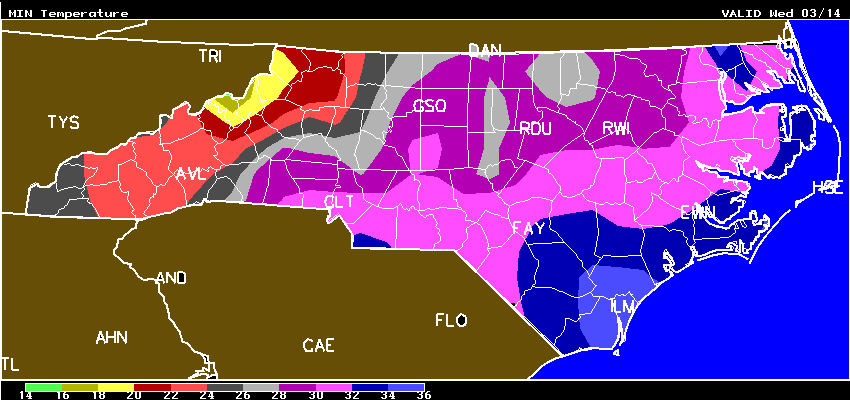 Fig. 1. These are “pretty cold” temperatures for tomorrow morning! But, nothing like last year during this very same week — see Fig. 2
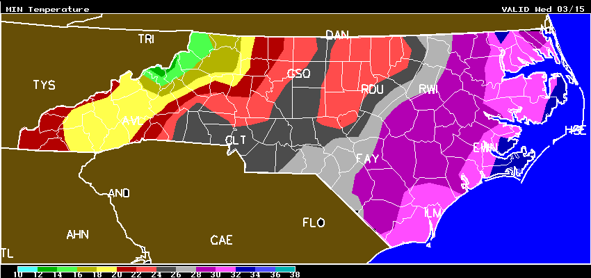 Fig. 2 (2017). One year ago NC growers experienced a devastating windborne freeze with minimum temperatures that were actually below what was shown on this AWIS forecast map that was issued on this same day of the week (Tue). Those lighter red areas were for lows of 22-24 F. But, the real problem last year had to do with “howling winds.” Thankfully, NC growers will not be facing anything like this tonight and tomorrow morning!
In checking in with a few NC growers this morning, I did learn that there was a light snow yesterday afternoon/evening in Sandhills (Fig. 3) and areas in ENC.
 Fig. 3. Sunrise in Sanford this morning on a strawberry farm that irrigated on top of row covers. This grower got about 1/2″ snow, and was concerned about cold injury to blossoms beneath the covers. A little after sunrise, the grower checked digital thermometer temperatures of blossoms in this field, and got measurements in range of 29.6 to 32.9 F. Later in day, he checked, and everything seemed to come through OK (see Fig. 4).
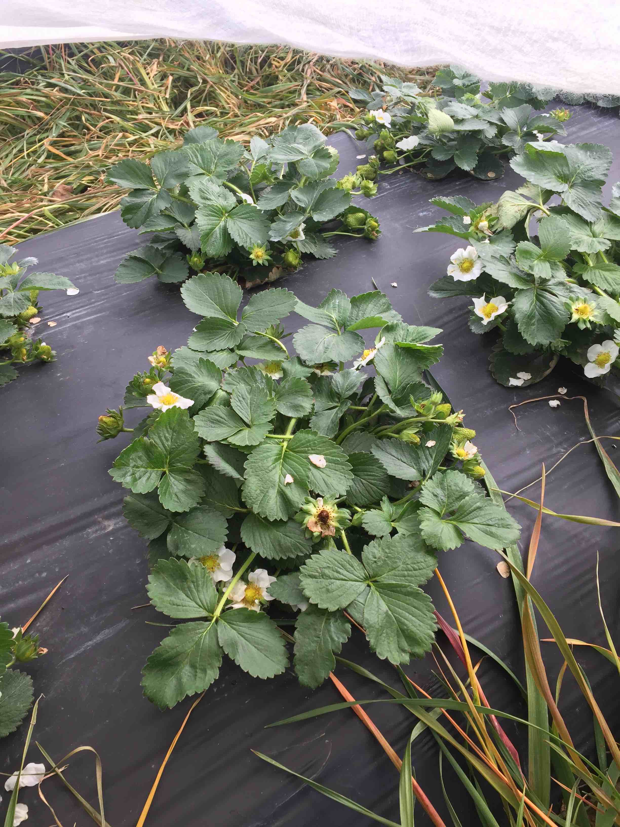 Fig. 4. Sweet Charlie plants from under the row cover after “being snowed on” and “irrigated on” last night and this morning! The only loss was a bloom that was killed last week – the blossom was in direct contact with the cover. Photo taken at about 5 p.m. Tuesday, March 13, 2018 (Sanford, NC). This has potential for Easter!
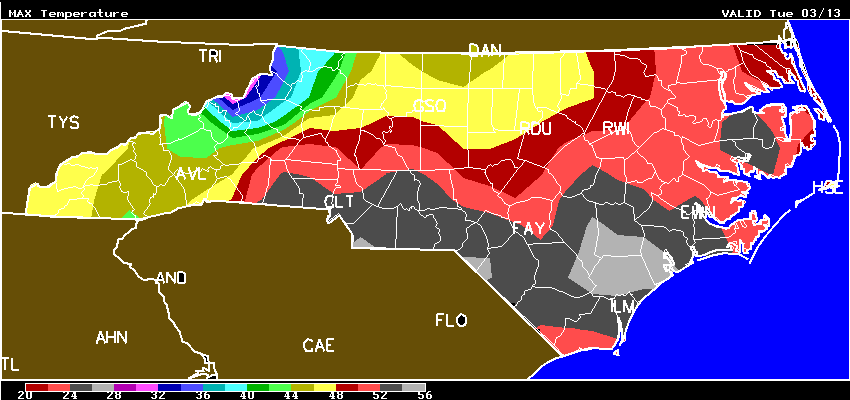 Fig. 5. Maximum temperatures today in NC in the Lee Co. area (below Wake and RDU) were only about 48 F.
With maximum temperatures today of only about 48 F in Lee County (where Sanford is located), the covers are now (5 p.m.) about half dry, so it may be necessary to repeat this procedure again tonight. The minimum temperature for Sanford on Wed. morning will be 29 F (Sanford Hourly), and that is “borderline dangerous.”
AND, the following morning (Thursday) will be even colder (Fig. 6), — going to 27 F, and there is a good possibility this grower will need to run water on top of covers tonight and tomorrow night as well.
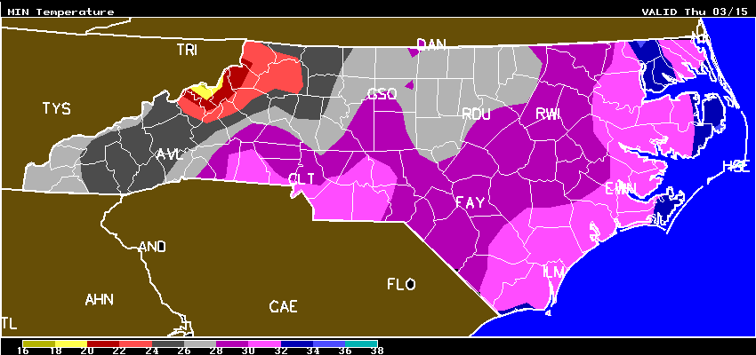 Fig. 6. Thursday morning minimums in NC.
So, please take a look at your temperature situation over these next few nights, and let’s hope for some warming conditions by the weekend, and a chance to FINALLY get these covers off!
North Carolina
10-DAY DETAILED HOURLY WEATHER FORECASTS
AWIS Weather Services, Inc. North Carolina Frost/Freeze Forecast
Produced at  306 p.m. CDT on Tue Mar 13 2018

... Forecast for Tonight ... Northeast NC Coast
Currituck/Camden/Pasquotank/Tyrrell Counties

**** FREEZE COLD LOCATIONS  ****
****  SCATTERED FROST  ****

Lowest Temperatures:      30 - 36
Elizabeth_City Min          31
Durations at/below 32:     0 -  3
Range Dewpoint Temps:     22 - 31
Range Wetbulb  Temps:     32 - 37
AVG Wind Direction/Speed:  SW  6     Long Periods of Calm
AVG Sky Condition:     Partly Cloudy

Extended Forecast: Range of Lowest Min Temperatures in the Above Zones
Min Temps Valid For Morning of Given Date (May NOT include ALL cold pockets)

  03/15/18  03/16/18  03/17/18  03/18/18  03/19/18  03/20/18
  --------  --------  --------  --------  --------  --------
   30 - 36   37 - 45   29 - 37   34 - 41   41 - 48   37 - 48
--------

East Central/SE NC Coast
Carteret/Pamlico Counties

**** FREEZE COLD LOCATIONS  ****
****  SCATTERED FROST  ****

Lowest Temperatures:      31 - 35
Morehead_City Min           35
Durations at/below 32:     0 -  2
Range Dewpoint Temps:     25 - 31
Range Wetbulb  Temps:     30 - 37
AVG Wind Direction/Speed:  SW  5     Long Periods of Calm
AVG Sky Condition:     Mostly Cloudy

Extended Forecast: Range of Lowest Min Temperatures in the Above Zones
Min Temps Valid For Morning of Given Date (May NOT include ALL cold pockets)

  03/15/18  03/16/18  03/17/18  03/18/18  03/19/18  03/20/18
  --------  --------  --------  --------  --------  --------
   28 - 32   41 - 45   35 - 39   40 - 43   45 - 50   44 - 54
--------

Southeast NC
NWS FORECAST ZONES 87-90,96-101

**** FREEZE COLD LOCATIONS  ****
****  SCATTERED FROST  ****

Lowest Temperatures:      30 - 35
Elizabethtown Min           34
Durations at/below 32:     0 -  4
Range Dewpoint Temps:     20 - 31
Range Wetbulb  Temps:     31 - 38
AVG Wind Direction/Speed:  NW  5     Long Periods of Calm
AVG Sky Condition:     Partly Cloudy

Extended Forecast: Range of Lowest Min Temperatures in the Above Zones
Min Temps Valid For Morning of Given Date (May NOT include ALL cold pockets)

  03/15/18  03/16/18  03/17/18  03/18/18  03/19/18  03/20/18
  --------  --------  --------  --------  --------  --------
   27 - 31   42 - 46   36 - 45   40 - 44   44 - 51   48 - 56
--------

North-Central NC
Franklin County Area

**** FREEZING TEMPERATURES ****
****    PATCHY FROST  ****

Lowest Temperatures:      26 - 32
Louisburg Min               26
Durations at/below 32:     1 - 10
Durations at/below 28:     0 -  4
Range Dewpoint Temps:     18 - 24
Range Wetbulb  Temps:     25 - 33
AVG Wind Direction/Speed:   W  4     Long Periods of Calm
AVG Sky Condition:     Mostly Cloudy

Extended Forecast: Range of Lowest Min Temperatures in the Above Zones
Min Temps Valid For Morning of Given Date (May NOT include ALL cold pockets)

  03/15/18  03/16/18  03/17/18  03/18/18  03/19/18  03/20/18
  --------  --------  --------  --------  --------  --------
   23 - 30   35 - 42   29 - 37   35 - 42   39 - 45   41 - 48
--------

North/Central NC
Alamance County Area

**** FREEZING TEMPERATURES ****
****    PATCHY FROST  ****

Lowest Temperatures:      26 - 32
Graham_AG Min               30
Durations at/below 32:     1 - 10
Durations at/below 28:     0 -  4
Range Dewpoint Temps:     18 - 24
Range Wetbulb  Temps:     25 - 33
AVG Wind Direction/Speed:  NW  5     Long Periods of Calm
AVG Sky Condition:     Mostly Cloudy

Extended Forecast: Range of Lowest Min Temperatures in the Above Zones
Min Temps Valid For Morning of Given Date (May NOT include ALL cold pockets)

  03/15/18  03/16/18  03/17/18  03/18/18  03/19/18  03/20/18
  --------  --------  --------  --------  --------  --------
   25 - 30   37 - 42   31 - 36   37 - 42   40 - 45   42 - 47
--------

South/Central NC
Richmond County Area

**** FREEZING TEMPERATURES ****
**** LITTLE IF ANY FROST ****

Lowest Temperatures:      29 - 33
Ellerbe Min                 33
Durations at/below 32:     0 -  5
Range Dewpoint Temps:     18 - 29
Range Wetbulb  Temps:     27 - 36
AVG Wind Direction/Speed:  NW  6     Periods of Calm
AVG Sky Condition:     Partly Cloudy

Extended Forecast: Range of Lowest Min Temperatures in the Above Zones
Min Temps Valid For Morning of Given Date (May NOT include ALL cold pockets)

  03/15/18  03/16/18  03/17/18  03/18/18  03/19/18  03/20/18
  --------  --------  --------  --------  --------  --------
   27 - 30   40 - 44   36 - 39   40 - 42   44 - 46   47 - 52
--------

Interior/EC-SE NC
Wayne County Area

**** FREEZE COLD LOCATIONS  ****
**** LITTLE IF ANY FROST ****

Lowest Temperatures:      30 - 36
Goldsboro_AG Min            32
Durations at/below 32:     0 -  5
Range Dewpoint Temps:     23 - 32
Range Wetbulb  Temps:     31 - 36
AVG Wind Direction/Speed:  NW  5     Long Periods of Calm
AVG Sky Condition:     Mostly Cloudy

Extended Forecast: Range of Lowest Min Temperatures in the Above Zones
Min Temps Valid For Morning of Given Date (May NOT include ALL cold pockets)

  03/15/18  03/16/18  03/17/18  03/18/18  03/19/18  03/20/18
  --------  --------  --------  --------  --------  --------
   27 - 31   40 - 45   34 - 39   38 - 43   43 - 49   46 - 54
--------

For more detailed information visit www.awis.com or call 888-798-9955. Copyright 2018 AWIS Weather Services, Inc. All rights reserved.